 Entries for 2025 have now closed—we look forward to seeing you next year!
Open to Students in Grades K–12
To encourage deeper inquiry into their world, the Missouri Botanical Garden is sponsoring a Community Investigations Storymap Challenge. The contest is open to students who attend a public, private, or charter school (or who homeschool) in Missouri.
To be eligible, students need to pursue a community-focused investigation which is enhanced by ArcGIS Online. Top entries in elementary (K–5), middle (6–8) and high school (9–12) divisions will be awarded a $100 gift card (or $50 each for a shared entry).
Process:
- Find something you’re interested in and do some research.
- Analyze what you find using ArcGIS Online and any other data tools you need.
- Present your findings in an ArcGIS Storymap.
Example links from last year’s winners:
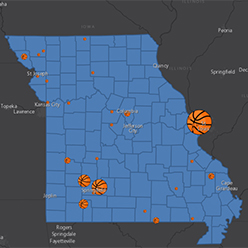 High School Sport Champions in Missouri: This project represents exemplary cartography and data analysis for a 5th grader, building off his interest in playing high school sports when he gets older.
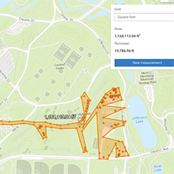 St. Louis Box Turtles: Male and Female Movement Differences: This project by two 6th graders extends work they did in a camp program tracking turtles by radio telemetry. Notice the thoughtful treatment of a massive data outlier.
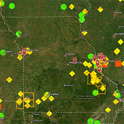
 Electric Vehicles, Charging and Environmental Effects: This project builds from a 9th grader’s interest in electric vehicles when his family bought a Rivian. After exploring different types of data, the author settled on finding locations in need of more chargers based on proximity to existing chargers and traffic counts.
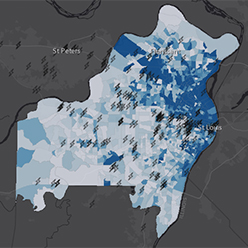
 Radiation in Missouri: This project was developed by an 11th grader interested in radioactive waste in Missouri, including an analysis of the demographics in affected communities.
Key points:
- Entries must be received by 11:59 pm on May 5, 2025 as two “public” links: (1) to an ArcGIS Storymap and (2) a link to the “item details” page supporting the Storymap. Each of these needs to be shared as “public” so they are open for readers without an ArcGIS license.
- Developing and submitting an entry requires a free license for ArcGIS Online from Esri.
- Students’ work must be original, with appropriate citations to the resources and data used. While various forms of AI may be used to support the work, all text, maps, and data visualizations need to be the original work of the student authors.
- Entries may be created by an individual student or a pair of students. These are not intended to be a group project.
- No more than 5 entries may come from a single school. If there are more, schools need to do local judging to determine which entries will represent the school.
- For 2025 we are substantially mirroring the national contest Esri used to run. As with that contest, “We look for a clear focus/topic/question/story, good and appropriate data, effective analysis, good cartography, thoughtful presentation, and complete documentation.”
Submission tips:
- Be sure your map and details page are “public”—meaning that they open for someone not logged into your account. Try the links in a “private browsing” or “incognito” window in your browser. These will ignore any login you may have in a regular window.
- How to find your map’s details page? Log in at arcgis.com and look under your content. Right click the link to your Storymap and submit that page link along with the link to your map. But first, be sure you fill out the details page to tell us about your work and where you got your data!
- Questions? Send a note to mapcontest@mobot.org and we’ll get back to you as soon as we can.